

GIS Mapping For Tree Management
GIS mapping has become a really handy tool for anyone involved in tree management. Whether you’re keeping track of an urban forest, checking out tree health in a park, or planning new plantings, GIS (Geographic Information Systems) can simplify things and save a lot of time. I’ll break down why GIS mapping is so useful for tree care, the tools you’ll need, steps to get started, tips to watch out for, and even answer a few of the most common questions people run into.
Why GIS Mapping is Really Useful for Tree Management
Trees play a big role in cities, rural land, and natural spaces. Managing them well means keeping up with locations, species, age, condition, and much more. Trying to handle all this with just pen and paper or spreadsheets can get out of control quickly, especially as the tree inventory grows. GIS mapping can bring everything together, letting you see data visually on a map, analyze trends, and plan with a lot more confidence.
GIS technology actually started out for land use and planning but has spread into agriculture, urban forestry, conservation, and many more sectors. It’s now a steady part of the toolkit for organizations like city public works, private tree care companies, and even volunteers who map trees in their neighborhoods.
How GIS Mapping Works for Trees
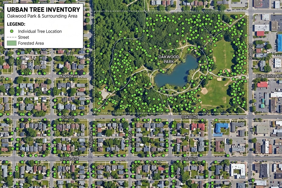
At its heart, a GIS is just a system that connects data to location. For tree management, that means every tree you care about gets recorded by its exact spot, along with details like species, size, health status, and more. Here’s a quick breakdown of what goes into a basic GIS tree inventory:
- Spatial Location: The latitude and longitude (or map reference) for each tree.
- Attributes: Information like species, height, diameter, health, maintenance history, and any notes about risks or special care.
- Photos: Images attached to a record help you keep track of problem spots or eye-catching highlights.
Many GIS platforms also let you attach documents, maintenance schedules, pest tracking, and even monitoring of soil and environmental conditions right to that tree’s digital record. You can build powerful maps that show patterns and make big jobs feel a bit less overwhelming.
Tools and Software Options Worth Checking Out
Starting off, you don’t need to be a tech whiz to use GIS for tree mapping. A lot of the current tools are designed for everyday users and can run on smartphones, tablets, or laptops. Here are some popular tools that fit a variety of needs and budgets:
- ArcGIS: Known for its powerful mapping abilities, ArcGIS lets professionals tackle almost any mapping job. There’s a learning curve but plenty of support online.
- QGIS: This one’s open source (free!), with a big online community. It works for both simple tree inventories and advanced analysis if you’re interested in learning a bit.
- TreePlotter: Made just for urban forestry, TreePlotter is web based and designed to be userfriendly for city foresters, contractors, and even volunteers.
- Fulcrum and Collector for ArcGIS: Both apps turn your phone or tablet into a mobile data collector, so you can record trees right in the field.
It’s useful to look at what your municipality or organization already uses, since sometimes there’s overlap with tools you already have for asset management, parks and rec, or other city services. A little research here can save you time down the road.
Simple Steps to Get Your GIS Tree Inventory Rolling
You don’t need to start with a massive mapping project. Here’s how people usually find success:
- Choose a GIS platform: Pick one that matches your needs and comfort level. Online options are a great way to get started.
- Set up your data fields: Decide what info you need for each tree: species, condition, planting date, maintenance notes, and so on.
- Gather equipment: A smartphone or tablet with GPS works for most inventory work. If you’re mapping trees in dense forests, a handheld GPS with higher accuracy might help.
- Start collecting data: Map a sample area first. This small pilot helps you iron out problems with data collection fields before gathering a huge dataset.
- Analyze and visualize: Once you’ve logged a few dozen (or hundred) trees, try filtering the map. For example, display only trees that need pruning or those of a certain species.
- Share and update: One major benefit of GIS is the ease of sharing live maps and updates in real time with your team or the public.
Starting small helps you build confidence, practice good data entry habits, and spot what’s working as you go.
What to Watch Out For: Common Challenges
As simple as it sounds, mapping trees with GIS isn’t always smooth sailing. Here are the pain points I’ve run into the most, with tips on how to get past them:
- GPS Accuracy: Smartphones are very convenient but sometimes can be several meters off, especially in heavy canopy or near buildings. Testing different devices and doublechecking coordinates on the map afterward can help catch any major errors.
- Data Management: As your inventory grows, missing or messy data can slow things down. Setting consistency rules early saves time—use dropdown menus and required fields where possible.
- Keeping Info Up to Date: Trees change! Scheduling regular updates or maintenance checks into your GIS process means your records stay useful.
- Training and Buy In: Teams may be wary of new systems. Dedicating a little time for walkthroughs and highlighting how easy it makes fieldwork can help win them over.
GPS Accuracy
I’ve found that checking coordinates against satellite or aerial photos is a fast way to catch big mistakes before you end up with a map that doesn’t match reality. Don’t be afraid to mark questionable locations and check them later.
Data Consistency
If you can, set up clear categories and choices for fields such as species or maintenance actions. This greatly reduces typos and makes searching or filtering your inventory much easier later.
Regular Updates
Adding a “last updated” field and building inventory checks into routine site visits keeps information current. Outdated tree maps can lead to missed risks or missed opportunities for better care.
Training
Demos and cheat sheets go a long way to help staff or volunteers get involved. Short, hands-on trainings with devices in the actual field make the process feel less intimidating.
Good planning and clear data entry rules really smooth the GIS mapping process and help you avoid most headaches.
More Advanced Tips for Tree Managers Using GIS
If you already have a basic inventory, there are a bunch of next-level cool GIS features worth giving a shot:
Heatmaps and Location Analysis: Mapping tree species diversity, canopy cover, or tree health across zones can help you spot areas needing extra care or those that can easily handle new plantings.
Pest and Disease Tracking: Connecting tree health data with pest outbreaks lets you pick up on and respond to bigger trends earlier—helping you act before serious trouble hits.
Public Engagement: Some communities create public tree maps or let locals suggest planting priorities with GIS tools. Seeing the city’s trees visually encourages more support and community involvement.
Integration with Work Orders: Many tree care companies and city departments now sync GIS with their work order systems, so when someone inspects a risky limb the follow up can be scheduled right away. Notes stay tied directly to the digital tree record, streamlining things.
Pushing further, you can mix in satellite imagery or drone data, blending that with your GIS layers. This makes it possible to monitor tree canopy, storm damage, or even urban heat impacts at a glance. Some cities even use GIS for long term planning, like tracking how planting efforts affect air quality or stormwater management over years.
Applications for Tree Management With GIS: Real-world Use Cases
- Urban Forestry: Keeping digital inventories, planning new planting projects, and tracking progress against sustainability goals.
- Parks and Green Spaces: Monitoring tree health, tracking replacements, and planning for more biodiversity in city parks.
- Utility Companies: Finding trees that might threaten power lines and getting proactive trimming on the calendar.
- Conservation Groups: Tracking rare or endangered species, mapping restoration projects, and measuring canopy cover growth over time.
All of these use cases benefit from spatial data analysis, and being able to see changes over time on a map rather than just in spreadsheets or stacks of paperwork makes a big difference. If you want to spot trends and make smarter decisions, GIS makes it much easier.
Increasingly, many urban forestry programs and private companies combine GIS mapping with smartphone photo logs and regular aerial surveys. That way, they can quickly spot storm damage, monitor for pests, or check canopy growth using a mix of in-field and remote data. This kind of combined approach is quickly becoming the “gold standard” for tree programs everywhere.
Frequently Asked Questions (FAQ)
Here are answers to a few questions I hear a lot from folks curious about getting started with GIS in tree management:
Question: Can I use my phone for collecting GIS tree data?
Answer: Absolutely! Most modern smartphones are accurate enough for city and park tree inventories, especially with tools designed for mobile data collection.
Question: How often should I update my tree inventory?
Answer: It depends on your needs, but checking each tree at least once every year or two is a great baseline. High traffic areas or locations where trees have more problems may need more frequent updates and monitoring.
Question: Is GIS mapping expensive?
Answer: It doesn’t have to be. There are excellent free options (like QGIS), and cloud-based software can be very budget friendly for small teams that want collaboration and mobile features. Look for free trials or community programs for extra help getting started.
GIS Mapping Makes Tree Management Smarter
GIS mapping offers a practical way to keep track of your trees and plan for their health and safety. From basic inventories to super detailed analyses and public engagement, there’s a level of GIS that works for almost any size project or team. I’ve seen the best results when organizations start small, keep data clear and current, and explore more advanced features as they gain confidence. Whether you care for a handful of landmark trees or an entire city’s green canopy, GIS mapping brings order, saves time, and lets you put your energy where it does the most good.
Tree management is changing fast, and GIS mapping sits at the heart of that popular trend. If you’re interested, now is the perfect time to try it out and see how much easier it can make your work!
Botanicus Plus a GPT for starters and experts
Botnicus Plus boasts an array of new features, enhancing its global appeal and user interaction. These include: 1) Multilingual Support for accessibility in various languages. 2) Virtual Tours of famous botanical gardens and historical plant sites. 3) A Botanical Identification Tool for users to upload and identify plants. 4) Seasonal Guides and Tips tailored to local climates and regions. 5) Opportunities for users to engage in Collaborative Projects and Citizen Science Initiatives. 6) Advice on Sustainable Gardening Practices. 7) Interactive Q&A Sessions with botany experts. 8) Personalized Plant Care Reminders for gardeners. These features enrich Botnicus Plus’s mission to provide comprehensive, interactive, and culturally rich botanical education, fostering a deeper connection with the natural world.
Enjoy!👒
Invest in your future
Take time to learn
Embark on your journey in affiliate marketing and website creation alongside an incredible community and myself. Invest in your future by dedicating time to learn and earn. Take all the time you need to master the basics before aiming higher. Give it a try and sign up for free. You won't regret it! Discover the possibilities for yourself...